Back to Howe

US 75 Widening Reshapes Howe's Economic Geography as One-Way Frontage Roads Take Effect

TxDOT's US 75 widening through Howe converts frontage roads to one-way and adds u-turn bridges, reshaping commerce, access, and long-run property values.

Maribel Sandoval

June 3, 20265 min read

Howe, a Grayson County town of fewer than 4,000 residents, is in the middle of one of the larger transportation-capacity investments in North Texas. The Texas Department of Transportation's ongoing US 75 widening project is replacing the town's primary commerce corridor with a six-lane mainline and new u-turn bridge geometry, a change that reshapes how local businesses, commuters, and freight move through the city. The June 1, 2026 TxDOT Paris District weekly road report sets out the current state of work and the constraints residents and travelers face.

TL;DR

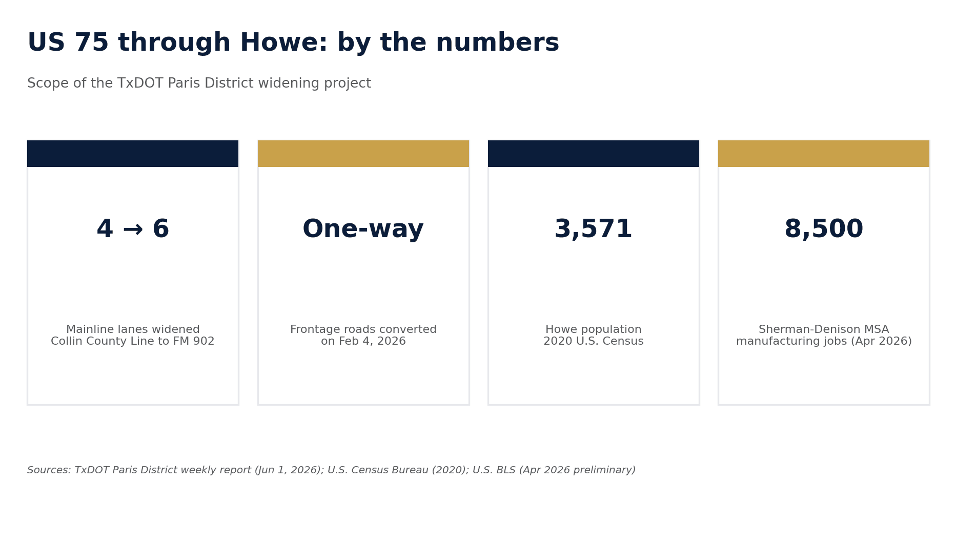
  • TxDOT is widening US 75 from four to six mainline lanes between the Collin County Line and FM 902.
  • Howe's US 75 frontage roads were converted to one-way traffic on February 4, 2026.
  • A new u-turn bridge is being built south of Hall Cemetery Road to manage cross-corridor movement.
  • Construction depresses adjacent retail in the short term; completed widenings tend to lift long-run frontage property values.
Infographic of key US 75 widening figures for Howe, Texas: 4 to 6 mainline lanes, one-way frontage roads converted Feb 4 2026, Howe population 3,571, Sherman-Denison MSA manufacturing jobs 8,500.

What the agency confirmed this week

According to the TxDOT Paris District report dated for the week of June 1, 2026, the US 75 project from the Collin County Line to FM 902 "will widen the US 75 mainlanes from the Collin County Line to FM 902 to six lanes" and "will also reconstruct the bridge at County Line Road and construct new u-turn bridges in Van Alstyne near Simmons Loop and in Howe south of Hall Cemetery Road" (Texas Department of Transportation, 2026).

The report further confirms that "the frontage roads in Van Alstyne and Howe on both the east and west sides of US 75 from County Line Road (CR 375/Panther Parkway) to Haning St. are one-way roads," and that "the US 75 frontage roads in Howe were converted to one-way traffic on February 04. This one-way conversion happened on both the east and west sides of US 75 from Hanning St to FM 902" (Texas Department of Transportation, 2026). The pavement work is complete and both lanes of the frontage roads are open to traffic, with the exception of work at Bear Road and Hall Cemetery Road. Occasional lane closures remain in place to complete backfill and striping.

The town in context

Howe's economic exposure to US 75 is structural. The town's population was 3,571 in the 2020 U.S. Census (U.S. Census Bureau, 2021). The Sherman-Denison Metropolitan Statistical Area, of which Howe is a part, reported preliminary total nonfarm employment of 55,000 jobs in April 2026, a year-over-year change of 1.1 percent, with an unemployment rate of 3.9 percent in March 2026 (U.S. Bureau of Labor Statistics, 2026). Manufacturing employment in the MSA was 8,500 jobs in April 2026, up 2.4 percent year over year.

Howe sits inside that labor market geography. The town's retail, fuel, lodging, and food-service businesses depend disproportionately on through-traffic visibility from US 75 and on the access-point design of the frontage road network. When a free-flowing two-way frontage system is replaced with one-way segments, the immediate effect is a redirection of trip patterns rather than a reduction in total trips. Some businesses gain northbound or southbound side dominance; others lose half of their walk-in visibility until drivers learn the new u-turn locations.

An economic lens on the trade-off

Transportation capacity expansions create two distinct economic phases for towns the size of Howe.

The construction phase generates short-term costs that are concentrated locally and largely uncompensated. Detours, dust, noise, and reduced street parking depress same-store sales for businesses immediately adjacent to the corridor. The TxDOT report itself acknowledges ongoing lane closures and conditions tied to remaining backfill and striping work (Texas Department of Transportation, 2026). For a small business, the construction phase functions as an unbudgeted negative shock to revenue, with limited recourse beyond pricing and marketing adjustments.

The post-completion phase, by contrast, capitalizes into land values. A six-lane mainline with controlled u-turn bridges typically lifts the long-run development potential of frontage parcels by improving accessibility and signaling permanence. The economic literature on highway widenings generally finds positive long-run impacts on commercial property values along upgraded corridors, with the magnitude depending on access design, signal density, and adjacent zoning. The presence of u-turn bridges, as specified in the TxDOT scope, is one of the design choices that determines whether the long-run lift flows to specific parcels or is distributed more evenly along the corridor.

From a public-finance perspective, the cost of the work itself is borne primarily by state and federal transportation funds rather than by the City of Howe directly, while the long-run gains in adjacent property valuation translate into a stronger local tax base. That structural asymmetry, state and federal capital outlay producing local tax appreciation, is one of the most consistent value transfers built into the U.S. highway program.

What to watch next

Two indicators will tell the story of how Howe absorbs the widening in coming quarters. The first is sales-tax allocation data for the city, which captures the construction-phase impact on local commerce in near real time. The second is commercial building-permit activity along the frontage road, which will signal whether private developers are pricing in the post-completion access improvements. Both data series are available through Texas Comptroller and city building department records.

The TxDOT Paris District weekly road report is updated on a recurring basis and remains the most reliable single source for current closures, lane-shift dates, and construction-phase schedules (Texas Department of Transportation, 2026).

References

Texas Department of Transportation. (2026, May 31). TxDOT June 1 Paris District weekly road report. North Texas e-News. https://www.ntxe-news.com/artman/publish/article_145816.shtml

U.S. Bureau of Labor Statistics. (2026, May 22). Sherman-Denison, TX economy at a glance. https://www.bls.gov/eag/eag.tx_sherman_msa.htm

U.S. Census Bureau. (2021). 2020 Census redistricting data: Howe town, Texas. https://data.census.gov

Share

Maribel Sandoval

Maribel Sandoval writes about community events, churches, and local life in Howe.

Related Stories

More in Texas

Texas

Texas Broadband Grant Rules Draw Senate Scrutiny

A Texas Senate committee hearing put new scrutiny on broadband grant rules after lawmakers questioned whether recent changes give satellite internet providers different treatment from traditional rural broadband companies.

Bree TanakaJuly 3, 20261 min read